To increase awareness of existing military operations areas (MOAs) in Canada, MOAs are being updated and added to aeronautical publications.
The updated MOAs described below will be published in the Designated Airspace Handbook (TP 1820E). Depictions of these areas will also be added or updated on the appropriate aeronautical charts.
The following MOA descriptions will appear in the Designated Airspace Handbook:
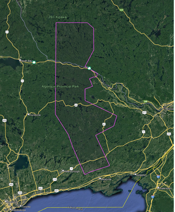
Algonquin MOA, ON:
The airspace within the area bounded by a line beginning at:
N44°44'00.00” W078°03'00.00” to
N44°58'00.00” W078°10'00.00” to
N45°20'00.00” W078°30'00.00” to
N47°00'00.00” W078°30'00.00” thence easterly along latitude N47°00'00.00” to
N47°00'00.00” W077°40'00.00” to
N46°54'00.00” W077°30'00.00” to
N46°30'00.00” W077°30'00.00” to
N46°12'00.00” W077°44'00.00” to
N46°04'02.04” W077°24'05.15” thence counter-clockwise along the arc of a circle of
2.5 miles radius centred on
N46°02'00.00" W077°22'00.00" to
N46°01'06.00" W077°25'21.00" to
N46°00'23.00" W077°28'11.00" to
N46°00'40.00" W077°30'10.00" to
N45°58'45.00" W077°37'00.00" to
N45°50'25.00" W077°32'16.00" to
N45°47'30.00” W077°44'00.00” to
N45°35'00.00” W077°44'00.00” to
N45°18'00.00” W076°55'00.00” to
N45°07'00.00” W077°00'00.00” to
N44°57'00.00” W077°28'00.00” to
N44°23'49.93” W077°06'53.85” to
N44°17'04.00" W077°36'46.00" to
N44°14'17.87” W077°44'58.76” to
N44°44'00.00” W078°03'00.00” the point of beginning.
Designated Altitude - Surface to 6000´
Time of Designation - Cont 13-05Z (DT 12-04Z), O/T by NOTAM
User Agency - Trenton Military Terminal Control (613) 965-2979, ATC Ops 8watcops@forces.gc.ca
Military transport aircraft conduct low level formation flights in this area under visual and instrument meteorological conditions, both day and night. During VFR weather conditions formations may depart the area and continue to operate low level.
NOT FOR NAVIGATION
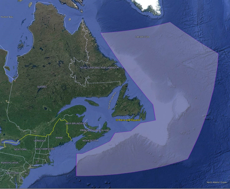
Elk MOA:
The airspace within the area bounded by a line beginning at:
N43° 00’ 00.00” W066° 00’ 00.00” thence easterly along latitude N43°00'00.00" to
N43° 00’ 00.00” W065° 00’ 00.00” to
N44° 30’ 00.00” W060° 00’ 00.00” to
N45° 30’ 00.00” W059° 00’ 00.00” thence easterly along latitude N45°30'00.00" to
N45° 30’ 00.00” W056° 00’ 00.00” to
N46° 20’ 00.00” W054° 00’ 00.00” thence easterly along latitude N46°20'00.00" to
N46° 20’ 00.00” W051° 00’ 00.00” to
N48° 24’ 00.00” W051° 00’ 00.00” to
N58° 30’ 00.00” W060° 20’ 00.00” thence easterly along latitude N58°30'00.00" to
N58° 30’ 00.00” W041° 30’ 00.00” to
N52° 00’ 00.00” W032° 00’ 00.00” to
N40° 00’ 00.00” W046° 00’ 00.00” thence westerly along latitude N40°00'00.00" to
N40° 00’ 00.00” W066° 00’ 00.00” to
N43° 00’ 00.00” W066° 00’ 00.00” point of beginning.
Designated Altitude - Surface to FL050
Time of Designation - Cont
User Agency - RJOC (Atlantic), SWO (902) 427-2501 CSN 427-2501,
rjocawatchofficer@forces.gc.ca or MAFF (902)427-2502
CSN 427-2502, rjoca.maff@forces.gc.ca
Maritime surveillance aircraft conduct daily all-weather operational flights in Area ELK. These aircraft are required to operate on various headings and altitudes up to and including FL050 and to make rapid climbs and descents without prior warning. Because of operational considerations they operate without navigation or identification lights during the hours of darkness and often without Selective Identification Feature (SIF)/Identification, friend or foe (IFF).
In the interest of Flight Safety, it is essential that RJOC (Atlantic) be informed in advance of all flights or proposed flights in or through Area ELK. Aircraft flight level(s), track and approximate times of ELK penetration and exit are required. Military aircraft are encouraged to communicate directly with RJOC (Atlantic). On prior request, frequencies will be assigned on which to report position and obtain ELK clearance. Anti-submarine warfare (ASW) aircraft will be routed clear of all known military and civil traffic. In-flight position reports or advisories, when not transmitted directly as above, may be relayed through Gander or Moncton ACC. These messages should specify “Pass to RJOC (Atlantic)”.
On request of the pilot when filing flight plans at departure points in North America, aircraft flight plans may be relayed through ATC channels to Moncton ACC for RJOC (Atlantic).
NOT FOR NAVIGATION
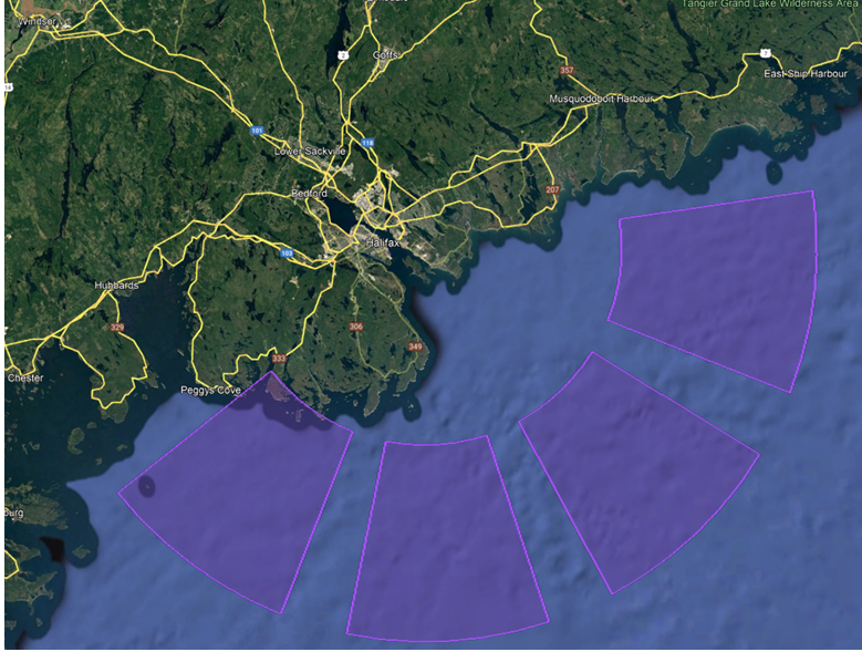
Shearwater MOA, NS:
Shearwater DIP Sector 1:
The airspace within the area bounded by a line beginning at:
N44° 37’ 57.39” W063° 08’ 59.49” to
N44° 37’ 51.60” W062° 47’ 59.17” thence clockwise along the arc of a circle of
30 miles radius centred on
N44° 37’ 59.33” W063° 29’ 59.84” (Shearwater, NS - TACAN) to
N44° 22’ 53.58” W062° 53’ 46.18” to
N44° 30’ 27.90” W063° 11’ 50.68” thence counter-clockwise along the arc of a circle of
15 miles radius centred on
N44° 37’ 59.33” W063° 29’ 59.84” (Shearwater, NS - TACAN) to
N44° 37’ 57.39” W063° 08’ 59.49” point of beginning
Shearwater DIP Sector 2:
The airspace within the area bounded by a line beginning at:
N44° 28’ 19.70” W063° 13’ 57.01” to
N44° 18’ 37.82” W062° 57’ 59.46” thence clockwise along the arc of a circle of
30 miles radius centred on
N44° 37’ 59.33” W063° 29’ 59.84” (Shearwater, NS - TACAN) to
N44° 09’ 46.99” W063° 15’ 44.59” to
N44° 23’ 53.40” W063° 22’ 50.50” thence counter-clockwise along the arc of a circle of
15 miles radius centred on
N44° 37’ 59.33” W063° 29’ 59.84” (Shearwater, NS - TACAN) to
N44° 28’ 19.70” W063° 13’ 57.01” point of beginning
Shearwater DIP Sector 3:
The airspace within the area bounded by a line beginning at:
N44° 23’ 12.96” W063° 26’ 21.90” to
N44° 08’ 26.44” W063° 22’ 45.78” thence clockwise along the arc of a circle of
30 miles radius centred on
N44° 37’ 59.33” W063° 29’ 59.84” (Shearwater, NS - TACAN) to
N44° 09’ 46.99” W063° 44’ 15.10” to
N44° 23’ 53.40” W063° 37’ 09.18” thence counter-clockwise along the arc of a circle of
15 miles radius centred on
N44° 37’ 59.33” W063° 29’ 59.84” (Shearwater, NS - TACAN) to
N44° 23’ 12.96” W063° 26’ 21.90” point of beginning
Shearwater DIP Sector 4:
The airspace within the area bounded by a line beginning at:
N44° 24’ 59.44” W063° 40’ 27.69” to
N44° 11’ 58.57” W063° 50’ 50.92” thence clockwise along the arc of a circle of
30 miles radius centred on
N44° 37’ 59.33” W063° 29’ 59.84” (Shearwater, NS - TACAN) to
N44° 22’ 53.58” W064° 06’ 13.51” to
N44° 30’ 27.90” W063° 48’ 09.01” thence counter-clockwise along the arc of a circle of
15 miles radius centred on
N44° 37’ 59.33” W063° 29’ 59.84” (Shearwater, NS - TACAN) to
N44° 24’ 59.44” W063° 40’ 27.69” point of beginning
Designated Altitude - Surface to 500’
Time of Designation - Cont 11Z-04Z (DT 10Z-03Z) O/T BY NOTAM
User Agency - 12 Wing ATC (902) 720-1292, W12ATC@forces.gc.ca
Maritime helicopters conduct essential over-water training and proficiency flights in the DIP Sectors on a daily basis. These flights often involve the use of sonobuoys, and helicopters routinely transition to/from the hover while in the area. Aircraft operating in or above this area should contact Shearwater ATC on 126.2 MHz or 231.95 MHz for advisory info.
NOT FOR NAVIGATION
This change will take effect 19 May 2022 at 0901 Coordinated Universal Time (UTC). The appropriate aeronautical publications will be amended.